Toronto · The east end

The east end

Victorian Cabbagetown, the view from Riverdale Park, the restaurants of the Danforth, and the boardwalk in the Beaches.

Map of The east end in Toronto: the City’s neighbourhoods in this part of the city are shaded, with the subway and LRT lines, main roads, parks, and ravines. Each neighbourhood in this guide is marked; choose one to jump to it.Bloor-YongeBroadviewCastle FrankCollegeCoxwellDonlandsKingOsgoodeQueenRosedaleSt. PatrickUnionVictoria ParkWellesleyCabbagetownRegent ParkRiverside, the West Don Lands,RiverdaleLeslievilleGreektownEast DanforthGerrard India BazaarThe BeachesThe Upper Beaches
Point to a neighbourhood or tap it; tap again to open itCity of Toronto Open Data and OpenStreetMap
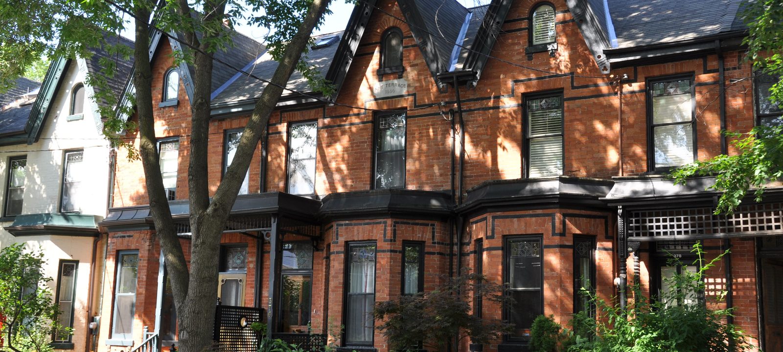
A row of red brick Victorian houses with gables and front gardens on a street in Cabbagetown, Toronto
Victorian houses in Cabbagetown.
Photo: Jay Woodworth from Brooklyn, NY, USA, CC BY 2.0

About The east end

East of downtown, the Don Valley cuts a deep green line through the city, and the neighbourhoods on its far side grew up as working class villages around the nurseries, brickyards, and factories of the 1800s. Riverdale joined the city in 1884, and East Toronto, the old railway town at the edge of the Beaches, in 1908.

Today the east end is one of the city’s most popular places to buy a house. Most homes are freehold, Victorian and Edwardian semis and row houses on narrow lots, with larger detached houses in parts of Riverdale and the Beaches, and condos along Queen Street East, the Danforth, and the new streets of the West Don Lands. Line 2 runs along the Danforth, and streetcars on Queen, King, Gerrard, and Dundas do the rest.

Schools. Public schools are run by the Toronto District School Board and Catholic schools by the Toronto Catholic District School Board, with French language schools from Conseil scolaire Viamonde and MonAvenir. Catchments follow the address, so it is worth checking one with the board before you buy.

Parliament Street east to the Don Valley

Cabbagetown

Cabbagetown is mostly semi detached Victorian houses, and the Cabbagetown Preservation Association calls it the largest continuous area of preserved Victorian housing in North America. It began as the village of Don Vale, around the Winchester Street bridge over the Don, and the name is said to come from the Irish immigrants who arrived from the late 1840s and grew cabbages in their front yards.

By the mid 20th century much of the area was poor, and parts were cleared for Regent Park. From the 1970s, the remaining Victorian streets were restored, and much of the neighbourhood is now covered by heritage conservation districts.

Homes

Victorian semis and row houses in brick, many in the bay and gable style, with some larger detached houses near Riverdale Park and the Necropolis. Heritage rules shape what can be changed on the front of a house, so we check the district plan with you before you buy.

Streets and landmarks

Parliament Street has the shops and restaurants, and Carlton Street, Winchester Street, and Sumach Street run east to the valley. The Toronto Necropolis, one of the oldest cemeteries in the city, and St. James Cemetery are at the north.

Parks and green space

Riverdale Park West and Riverdale Farm, a small working farm run by the City, look over the Don Valley, and Allan Gardens is a short walk west.

Getting around

The 506 Carlton streetcar runs along Carlton Street to College station, the 65 Parliament bus runs north to Castle Frank station on Line 2, and the Don Valley Parkway is close.

Day to day

Victorian streets, Riverdale Farm at the end of the road, the Necropolis and the Don Valley trails close by, and downtown a walk or a short streetcar ride away.

On the City’s neighbourhood map: Cabbagetown-South St. James Town.

Parliament Street, Bloor Street to Shuter Street

Regent Park and St. James Town

Regent Park was built in the late 1940s as Canada’s largest public housing project, on land that had been part of Cabbagetown. By the 2000s its buildings were wearing out, and the City and Toronto Community Housing began a long rebuild in 2005 that is mixing new social housing with market condos, a new park, an aquatic centre, and the Daniels Spectrum arts centre.

North of Wellesley Street, St. James Town is the city’s largest high rise community, a cluster of apartment towers built in the 1960s on the Towers in the Park model, many named for Canadian cities.

Homes

In Regent Park, new condo towers and townhouses sit beside rebuilt Toronto Community Housing buildings. St. James Town is almost all rental apartment towers, with a few condos at the edges.

Parks and green space

Regent Park, the new central park, with the Regent Park Athletic Grounds and the aquatic centre beside it, and Wellesley Park and Riverdale Park West to the east.

Getting around

The 505 Dundas and 506 Carlton streetcars run through Regent Park, and Sherbourne and Castle Frank stations on Line 2 are close to St. James Town.

Day to day

The new central park, the aquatic centre, and Daniels Spectrum are the local gathering places, and downtown is a short walk or streetcar ride west.

On the City’s neighbourhood map: Regent Park, North St. James Town. A smaller local name here is Trefann Court.

Queen Street East at the Don, and the land west of the river

Riverside, the West Don Lands, and the Canary District

Riverside is the stretch of Queen Street East just across the Don, with the Broadview Hotel, a red sandstone Romanesque block from the early 1890s, as its landmark. West of the river, the West Don Lands are a former industrial area being rebuilt by Waterfront Toronto as a mixed use neighbourhood. The Canary District, named for the old Canary Restaurant, began as the athletes’ village for the 2015 Pan Am Games.

Homes

New condos and townhouses in the West Don Lands and the Canary District, some of them affordable rental, and Victorian row houses and semis on the side streets of Riverside.

Parks and green space

Corktown Common, a park built on a flood protection landform, with a splash pad and marsh, and the Don River trails.

Getting around

The 501 Queen and 504 King streetcars cross the Don here, and the Ontario Line, under construction, is planned to have Leslieville station on the rail bridge over Queen Street East, where Riverside meets Leslieville.

Day to day

Queen Street East’s shops and the Broadview Hotel are close, Corktown Common and the Don Valley trails are a short walk, and the Distillery District is just across the river.

On the City’s neighbourhood map: South Riverdale, Moss Park.

The Don Valley east to Jones Avenue

Riverdale

Riverdale runs from the Don Valley east to Jones Avenue, between Danforth Avenue and Lake Shore Boulevard. It joined the City of Toronto in 1884. People often speak of North Riverdale, the quieter residential streets near the Danforth, and South Riverdale, which reaches down to the lake and takes in Leslieville.

East Chinatown, centred on Gerrard Street East between Broadview Avenue and Carlaw Avenue, began here in the early 1970s as Chinese Canadian families and businesses moved east. Bridgepoint Health, on the site of the old Riverdale Hospital at Broadview Avenue and Gerrard Street East, is the local hospital.

Homes

Victorian and Edwardian semis and detached houses on long, straight streets, many with front porches. North Riverdale has some of the larger houses, especially near Riverdale Park and Withrow Park, and there are newer condos and townhouses near the main streets.

Streets and landmarks

Broadview Avenue runs along the top of the valley, with one of the best views of the skyline from Riverdale Park East. The Danforth, Gerrard Street East, and Queen Street East have the shops.

Parks and green space

Riverdale Park East, with its hill, pool, and track, and Withrow Park, with its farmers’ market, rink, and off leash area.

Getting around

Broadview, Chester, Pape, and Donlands stations on Line 2 are along the Danforth, and the 504 King, 505 Dundas, and 506 Carlton streetcars cross the neighbourhood. The Ontario Line is planned to run through it, with stations at Gerrard Street and Pape.

Day to day

Riverdale Park has its hill and skyline view, Withrow Park has a Saturday market, and the Danforth and Gerrard Street cover shopping and dinner.

On the City’s neighbourhood map: North Riverdale, South Riverdale, Blake-Jones, Playter Estates-Danforth.

Queen Street East, McGee Street to Coxwell Avenue

Leslieville

Leslieville began in the 1850s as a village around the Toronto Nurseries of George Leslie and his sons, and most of its early residents worked as gardeners or in the brickyards. Alexander Muir, who wrote The Maple Leaf Forever, was the first principal of Leslieville Public School. The neighbourhood is part of the larger South Riverdale area.

As the factories left, the area drew artists, families, and the film studios on Eastern Avenue. Queen Street East is now lined with cafés, restaurants, antique shops, and design stores.

Homes

Small Victorian and Edwardian row houses and semis built for workers, many renovated, along with some detached houses, factory lofts, and new townhouses and mid rise condos on Queen Street East and Eastern Avenue.

Streets and landmarks

Queen Street East is the main street, and Gerrard India Bazaar is at its north edge. Jimmie Simpson Park and its recreation centre are at the west end.

Parks and green space

Jimmie Simpson Park, Greenwood Park, with its outdoor pool, and the lake at Ashbridges Bay and the Leslie Street Spit to the south.

Getting around

The 501 Queen streetcar runs along Queen Street East, the 504 King and 506 Carlton streetcars run nearby, and the Ontario Line is planned to have Leslieville station on the rail bridge over Queen Street East, where Riverside meets Leslieville.

Day to day

Queen Street East has cafés, brunch spots, and small shops, Jimmie Simpson Park is the local park, and the beaches are a short ride east.

On the City’s neighbourhood map: South Riverdale, Greenwood-Coxwell.

Danforth Avenue, Chester Avenue to Dewhurst Boulevard

Greektown and the Danforth

Greektown, also known as the Danforth, runs along Danforth Avenue between Chester Avenue and Dewhurst Boulevard. The street is named for Asa Danforth Jr., an American contractor hired in 1799 to open a road east of York. Most of its buildings date from 1910 to the late 1920s, and after the Second World War it became one of the main areas where Greek immigrants settled in the city.

The Taste of the Danforth, a free food festival held each August, draws huge crowds to the street. Playter Estates, the quiet pocket north of the Danforth around Playter Boulevard near the valley, is one of the area’s prettiest streets.

Homes

Detached and semi detached houses from the early 1900s, many with front porches, on the streets north and south of the Danforth, with flats above the shops and a few newer condos on the avenue itself.

Parks and green space

Withrow Park to the south, the Don Valley trails to the west, and Riverdale Park East.

Getting around

Line 2 runs right under Danforth Avenue, with Broadview, Chester, Pape, Donlands, Greenwood, and Coxwell stations, and Pape is planned to connect with the Ontario Line.

Day to day

Danforth Avenue has a long run of restaurants with the subway underneath, and Withrow Park and the Don Valley trails are close.

On the City’s neighbourhood map: Danforth, Playter Estates-Danforth, North Riverdale, Blake-Jones.

Danforth Avenue, Greenwood Avenue to Victoria Park Avenue

East Danforth and Danforth Village

East of Greektown, Danforth Avenue runs on past Greenwood Avenue to Victoria Park Avenue, at the edge of Scarborough. The area is often called East Danforth or Danforth Village, and it began in the 1800s as the Coleman postal village at Danforth Avenue and Dawes Road. Apartment towers went up in the 1960s and 1970s at Crescent Town and around Main Street, but most of the area is still low rise.

Homes

Detached and semi detached houses, many from the 1910s to the 1940s, on streets north and south of the Danforth, with apartment towers at Crescent Town and Main Square.

Parks and green space

East Lynn Park, with its farmers’ market, Stan Wadlow Park and the Taylor Creek ravine to the north, and Monarch Park to the west.

Getting around

Woodbine, Main Street, and Victoria Park stations on Line 2, and Danforth GO station, on the Lakeshore East line, near Main Street.

Day to day

The Danforth’s shops and the Line 2 stations are close, East Lynn Park has its Thursday market, and Taylor Creek is a short walk north.

On the City’s neighbourhood map: East End-Danforth, Danforth, Woodbine Corridor.

Gerrard Street East, Greenwood Avenue to Coxwell Avenue

Gerrard India Bazaar and Greenwood-Coxwell

Gerrard India Bazaar, also known as Little India, is the city’s best known South Asian shopping street, with Indian, Pakistani, Bangladeshi, Nepali, and Sri Lankan restaurants, sweet shops, grocers, and clothing stores along Gerrard Street East. It grew from the 1970s, and its festival each summer fills the street.

The streets around it, between Greenwood Avenue and Coxwell Avenue, are quiet residential blocks, and Monarch Park is close by.

Homes

Semis and row houses from the early 1900s on narrow lots, with some detached houses, and a few new townhouse and condo buildings on the main streets.

Parks and green space

Monarch Park, with its pool and rink, and Greenwood Park, along with the small Maple Leaf Forever Park.

Getting around

The 506 Carlton streetcar runs along Gerrard Street East, and Greenwood and Coxwell stations on Line 2 are a short bus ride north.

Day to day

Gerrard Street East has sweet shops, grocers, and restaurants, Leslieville and the Beaches are a short ride away, and the side streets are quiet.

On the City’s neighbourhood map: Greenwood-Coxwell.

Queen Street East, Coxwell Avenue to Victoria Park Avenue

The Beaches

The Beaches, which many locals call the Beach, takes its name from the four beaches along its shore. It runs from Coxwell Avenue to Victoria Park Avenue, between Kingston Road and the lake. Much of it was once part of East Toronto, the railway town that joined the city in 1908, and summer cottages here gave way to year round houses in the early 1900s.

Queen Street East is the main street, with independent shops, cafés, and restaurants, and a boardwalk runs along the lake from Woodbine Beach to Balmy Beach. The R. C. Harris Water Treatment Plant, an Art Deco landmark built in the 1930s and opened in 1941, stands at the east end.

Homes

The side streets are mostly lined with semi detached houses and large Victorian, Edwardian, and newer houses, many with porches, on streets that run down toward the lake. There are low rise apartments and a few row houses, and some newer mid rise condos along Queen Street East and Kingston Road.

Parks and green space

Kew Gardens, the only waterfront park that reaches up to Queen Street, Woodbine Beach and Woodbine Park, Glen Stewart Park and its ravine, and Balmy Beach.

Getting around

The 501 Queen streetcar runs along Queen Street East, and buses run north to Line 2. Danforth GO and the Lakeshore East line are a short ride north.

Schools

Malvern Collegiate Institute and Balmy Beach Community School are among the local public schools.

Day to day

The boardwalk, Kew Gardens, and the shops and cafés on Queen Street East are a short walk from most streets, and the Queen streetcar runs into town.

On the City’s neighbourhood map: The Beaches.

North of Kingston Road, Coxwell Avenue to Victoria Park Avenue

The Upper Beaches

The Upper Beaches runs north of Kingston Road from Coxwell Avenue to Victoria Park Avenue, up to the rail tracks. The western part was once the village of Norway, and the larger area was part of the Town of East Toronto. The name Upper Beaches came into use in the early 2000s, and it has stuck.

Homes

Detached and semi detached houses from the early 20th century, many with front porches, along with some newer infill houses and townhouses.

Parks and green space

Williamson Park Ravine, Fairmount Park, and Glen Stewart Park, with the beaches a short walk south.

Getting around

Buses along Woodbine Avenue, Main Street, and Coxwell Avenue run to Line 2, and the 501 Queen and 506 Carlton streetcars are close. Danforth GO is at the north edge.

Day to day

The beach is a short walk down the hill, Danforth GO and Main Street station are close, and the ravines at Williamson Park and Glen Stewart are quiet places for a walk.

On the City’s neighbourhood map: Woodbine Corridor, East End-Danforth.