Toronto · The west end

The west end

High Park, the Humber, and the lake, with old main streets on Roncesvalles, Bloor, Dundas, and St. Clair.

Map of The west end in Toronto: the City’s neighbourhoods in this part of the city are shaded, with the subway and LRT lines, main roads, parks, and ravines. Each neighbourhood in this guide is marked; choose one to jump to it.BathurstCaledoniaCedarvaleChaplinChristieDufferinDundas WestDupontFairbankForest HillHigh ParkJaneKeeleKeelesdaleMount DennisOakwoodOld MillOssingtonRunnymedeSt. Clair WestParkdaleRoncesvallesHigh ParkSwanseaBloor West VillageThe JunctionThe Junction TriangleWallace EmersonCorso Italia
Point to a neighbourhood or tap it; tap again to open itCity of Toronto Open Data and OpenStreetMap
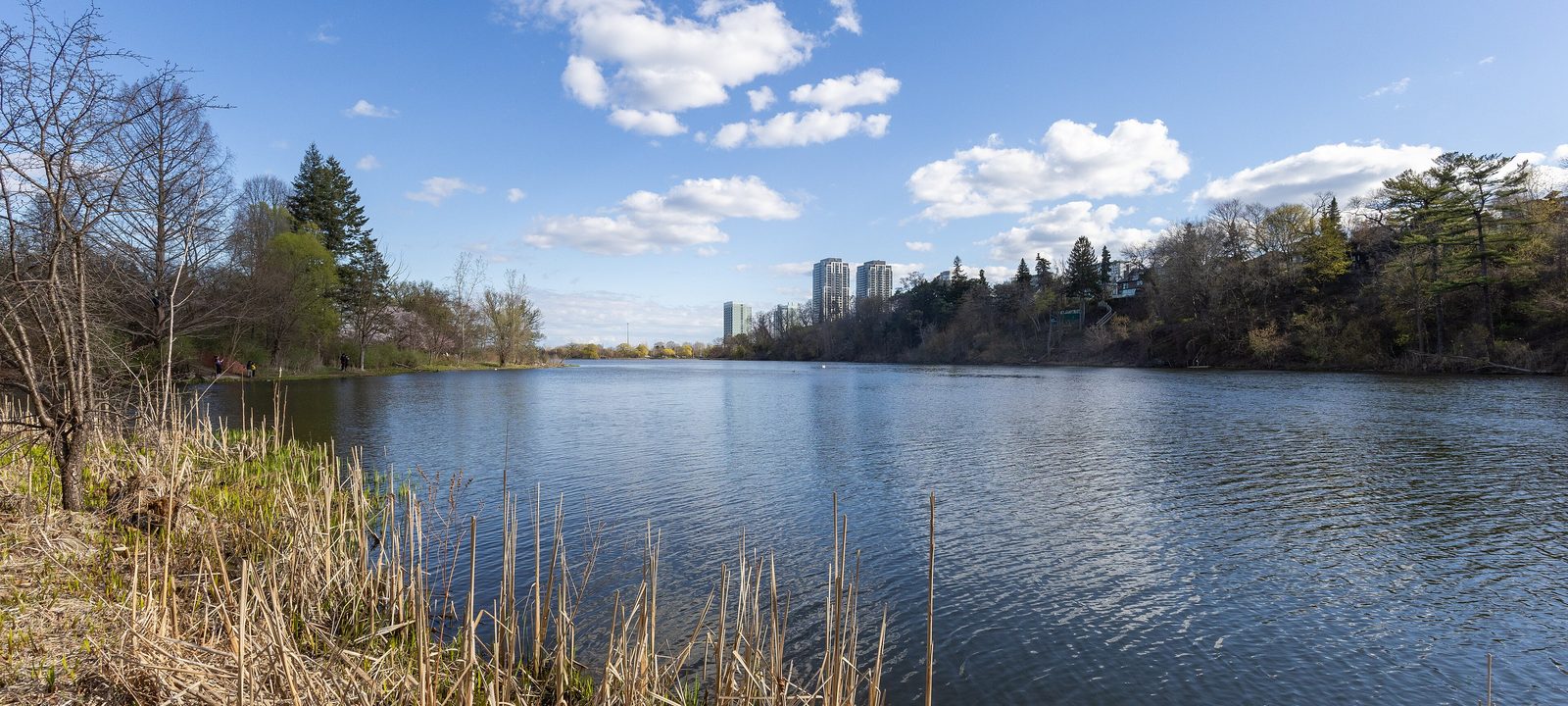
Grenadier Pond in High Park in spring, with reeds in the foreground and towers on the far shore
Grenadier Pond, in High Park.
Photo: Dillan Payne, CC BY-SA 4.0

About The west end

The west end grew from villages and railway towns: Parkdale and Brockton on the lake, the City of West Toronto at the Junction, and Swansea on the Humber. Toronto took them in between the 1880s and the 1960s, and each kept a main street and a name of its own.

This is a part of the city of houses, big parks, and neighbourhood shops. Most homes are freehold, from Victorian and Edwardian semis to larger detached houses near High Park, with apartment buildings near the subway and a growing number of condos on Bloor Street, Dundas Street, and the old industrial land. Line 2 runs along Bloor Street, and the Kitchener GO line and the UP Express stop at Bloor station.

Schools. Public schools are run by the Toronto District School Board and Catholic schools by the Toronto Catholic District School Board, with French language schools from Conseil scolaire Viamonde and MonAvenir. Catchments follow the address, so it is worth checking one with the board before you buy.

Queen Street West, Dufferin Street to Roncesvalles Avenue

Parkdale

Parkdale began in the 1850s as a settlement west of the city, was incorporated as a village in 1879, and joined Toronto in 1889. For the first half of the 20th century it was a well to do lakeside suburb, and many of its large Victorian houses survive.

The Gardiner Expressway, built in the 1950s, cut Parkdale off from its beaches, and many big houses were split into rooming houses and flats. Today it is a diverse, close knit neighbourhood with a lot of rental housing, a long main street on Queen Street West, and a strong Tibetan community whose shops and restaurants give the street its nickname of Little Tibet.

Homes

Semi detached and detached houses from the 19th and early 20th centuries on most side streets, some of them grand Victorian houses, many divided into units. Jameson Avenue and Tyndall Avenue are lined with apartment buildings from the 1950s to the 1970s, and Parkdale has a higher than average share of renters.

Streets and landmarks

Queen Street West is the main street, with cafés, Tibetan restaurants, and vintage shops. King Street West meets Queen Street and Roncesvalles Avenue at the west end.

Parks and green space

Across Lake Shore Boulevard are Sunnyside Park, the Sunnyside Pavilion, the Gus Ryder Pool, and Marilyn Bell Park, all along the waterfront trail.

Getting around

The 501 Queen and 504 King streetcars run through it, and Exhibition GO station, on the Lakeshore West line, is at the east end. Line 2 is a short ride north at Dundas West.

Day to day

Queen Street West, with its Tibetan restaurants and old storefronts, is the main street, the lake and the waterfront trail are just across Lake Shore Boulevard, and downtown is a short ride on the King or Queen streetcar.

On the City’s neighbourhood map: South Parkdale.

Roncesvalles Avenue, Queen Street to Dundas Street West

Roncesvalles

Roncesvalles, often called Roncy or Roncesvalles Village, is centred on Roncesvalles Avenue, which runs about 1.7 kilometres from the corner of King Street and Queen Street up to Dundas Street West. High Park is on its west side. It is mostly residential, with a commercial strip the whole length of the avenue made up of small businesses, churches, and institutions.

The neighbourhood has long had a large Polish community, and the Polish delis, bakeries, and St. Casimir’s Church are still part of the street, alongside cafés, restaurants, and the Revue Cinema.

Homes

Mostly two and a half and three storey Victorian and Edwardian semis and detached houses, many with front porches and gables, on streets running east and west from the avenue. A few low rise apartments and condos are near Queen Street and Dundas Street.

Streets and landmarks

Roncesvalles Avenue has the shops, the Revue Cinema, and the Roncesvalles branch of the Toronto Public Library. Sorauren Avenue, a block east, has Sorauren Park and its farmers’ market.

Parks and green space

High Park is across Parkside Drive, Sorauren Avenue Park is to the east, and West Lodge Park is a quieter local green.

Getting around

The 504 King streetcar runs the length of Roncesvalles Avenue, Dundas West station on Line 2 is at the north end, and Bloor GO and the UP Express are next door to it.

Day to day

Roncesvalles Avenue has the bakeries, the Revue Cinema, and the library, High Park is a block west, and Sorauren Park’s Monday market is a short walk east.

On the City’s neighbourhood map: Roncesvalles.

Around the park, Bloor Street to Annette Street

High Park and High Park North

High Park opened to the public in 1876, from land John George Howard left to the city. It covers about 161 hectares, and a third of it is still natural, with a rare oak savannah. Howard’s Regency cottage, Colborne Lodge, built in 1837, still stands at its south end, and Grenadier Pond lies along its west side. The park has gardens, sports fields, a zoo, and the cherry trees that draw crowds every spring.

North of Bloor Street, the High Park North neighbourhood runs up to Annette Street, between Runnymede Road and the rail tracks. The part east of Keele Street is sometimes called the West Bend.

Homes

The oldest houses, from the late 1800s and early 1900s, are mostly Victorian, Edwardian, and Tudor style, two and three storey detached brick houses, many with leaded and stained glass windows. North of the park there are also high rise apartment buildings built after the Bloor subway opened, many of them rentals.

Streets and landmarks

Bloor Street West is the main street, with shops below flats. Keele Street and Dundas Street West run north through the neighbourhood.

Parks and green space

High Park itself, and smaller greens such as Lithuania Park and the Ravina Gardens to the north.

Getting around

Keele, High Park, and Runnymede stations on Line 2 are along Bloor Street, and Dundas West station and Bloor GO are at the east end.

Day to day

High Park, with Grenadier Pond, trails, the zoo, and summer theatre, is a short walk from most streets, and Bloor Street’s shops and the subway are at the north edge.

On the City’s neighbourhood map: High Park North, High Park-Swansea.

High Park west to the Humber River

Swansea

Swansea runs from High Park west to the Humber River, between Bloor Street and the lake. It was a separate municipality, the Village of Swansea, and it joined Metropolitan Toronto in 1953 and the City of Toronto in 1967.

It is mostly residential. The largest homes sit at the west edge of High Park overlooking Grenadier Pond, and along Riverside Drive and the Brule Gardens enclave above the Humber. The Queensway was built through the old Swansea Works lands in the 1950s.

Homes

A mix of detached houses, many on winding streets, from 1920s and 1930s houses to newer ones, with some semis and townhouses and a cluster of apartment buildings near the Queensway and Windermere Avenue.

Parks and green space

High Park on the east, the Humber Marshes and the Humber valley trails on the west, and the waterfront at the south end.

Getting around

Runnymede and Jane stations on Line 2 are on Bloor Street, and the 501 Queen streetcar runs along the Queensway at the south.

Schools

Swansea Junior and Senior Public School is in the village.

Day to day

Streets here are quiet and leafy, with High Park on one side, the Humber valley on the other, and the lake at the south end.

On the City’s neighbourhood map: High Park-Swansea.

Bloor Street West, South Kingsway to Ellis Park Road

Bloor West Village

Bloor West Village is a residential neighbourhood and shopping district on Bloor Street West between the South Kingsway and Ellis Park Road, with hundreds of shops, restaurants, and services. Its business area was one of the first business improvement areas in the world. The City’s name for the neighbourhood is Runnymede-Bloor West Village, and it is part of the former City of York.

Homes

Mostly detached and semi detached houses from the 1910s to the 1930s, many with front porches and stained glass, on streets running north from Bloor Street.

Streets and landmarks

Bloor Street West is the village, with bakeries, delis, and cafés, and the old Runnymede Theatre, a 1927 movie palace, now holds a shop.

Parks and green space

High Park is a short walk south and east, the Humber valley is to the west, and Baby Point and the Lambton parks are close.

Getting around

Runnymede and Jane stations on Line 2 are right on Bloor Street.

Schools

Runnymede Junior and Senior Public School and Runnymede Collegiate Institute are in the area.

Day to day

Bloor Street West is a walkable village of bakeries, delis, and cafés, the subway runs right under it, and High Park and the Humber valley are close by.

On the City’s neighbourhood map: Runnymede-Bloor West Village.

Dundas Street West and Keele Street

The Junction

The Junction is named for the West Toronto Diamond, where four railway lines cross. It was an independent city, West Toronto, until it joined Toronto in 1909. It grew quickly in the late 1800s as a manufacturing town of foundries, mills, furniture makers, and meat packers, with the Stockyards in its northeast corner.

Residents voted to ban the sale of alcohol, and the area stayed dry until 1998. Since then Dundas Street West has filled with restaurants, bars, antique and design shops, and small breweries, while the houses around it are much as they were in the railway town.

Homes

Victorian and Edwardian detached and semi detached houses, many of brick, along with workers’ houses and some lofts and newer condos on Dundas Street West and on old industrial land.

Streets and landmarks

Dundas Street West between Keele Street and Runnymede Road is the main street. The Stockyards area to the northeast has big box stores where the meat packing plants used to be.

Parks and green space

Baird Park, Runnymede Park, and the West Toronto Railpath, which starts near Dundas Street and runs south along the rail line.

Getting around

The 40 Junction and 41 Keele buses run through it, Keele and Dundas West stations on Line 2 are a short ride south, and Bloor GO and the UP Express are close. A new GO station has been planned at St. Clair Avenue West.

Schools

Annette Street Junior and Senior Public School and Humberside Collegiate Institute are nearby.

Day to day

Dundas Street West has shops, cafés, and small breweries, and the West Toronto Railpath is close by.

On the City’s neighbourhood map: Junction Area.

Between the railway lines, west of Lansdowne Avenue

The Junction Triangle

The Junction Triangle is a small neighbourhood just west of Lansdowne Avenue, surrounded on all three sides by railway lines. Bloor Street crosses the middle, Dupont Street runs near the north edge, and Dundas Street West is close to the south. The City has used the name since the 1970s, and in 2010 residents voted to keep it.

Old factories along the tracks have been turned into lofts, offices, and studios, and the Museum of Contemporary Art Toronto opened in the former Tower Automotive building on Sterling Road in 2018.

Homes

Small Victorian and Edwardian row houses and semis on narrow streets, factory lofts, and new townhouses and condos on old industrial land north of the tracks, around Sterling Road and Lansdowne Avenue.

Parks and green space

The West Toronto Railpath runs through the neighbourhood, and Wallace Emerson Park and the new parks on Sterling Road are close.

Getting around

Lansdowne and Dundas West stations on Line 2 are close, and Bloor GO and the UP Express are at the west edge.

Day to day

Many people use the Railpath to walk or bike to work or the park, and the Museum of Contemporary Art Toronto is on Sterling Road.

On the City’s neighbourhood map: Junction-Wallace Emerson.

North of Bloor Street, Christie Street to the railway

Wallace Emerson and Dovercourt Village

Wallace Emerson is named for the corner of Wallace Avenue and Emerson Avenue near its centre. It runs north of Bloor Street from Dufferin Street west to the railway, and the Bloor Street shops here are known as Bloordale Village. East of Dufferin, Dovercourt Village runs to Christie Street, with the Bloorcourt Village shops along Bloor Street. Dovercourt was founded in the 1870s and annexed by the City in 1910.

Homes

Mostly single family houses, semis and row houses from the early 1900s, many now divided into apartments, with new condos rising along Bloor Street and Dufferin Street.

Streets and landmarks

Bloor Street West has the shops and restaurants of Bloorcourt and Bloordale, and the Galleria site at Dufferin Street and Dupont Street is being rebuilt as a new neighbourhood.

Parks and green space

Dovercourt Park, Christie Pits, and Wallace Emerson Park, with its community centre and pool.

Getting around

Ossington, Dufferin, and Lansdowne stations on Line 2 are along Bloor Street, and the 29 Dufferin bus runs north and south.

Day to day

Bloor Street’s shops and the Line 2 stations are close, the Galleria lands are being rebuilt with a new park and community centre, and the side streets are quiet.

On the City’s neighbourhood map: Junction-Wallace Emerson, Dovercourt Village.

St. Clair Avenue West, Westmount Avenue to Lansdowne Avenue

Corso Italia and St. Clair West

Corso Italia runs along St. Clair Avenue West from just east of Dufferin Street to Lansdowne Avenue, inside the City’s larger Corso Italia-Davenport neighbourhood. It is often called the city’s second Italian enclave, after Little Italy on College Street, with cafés, clothing and shoe shops, food markets, gelaterias, and bakeries, and strong Latin American and Portuguese communities too.

It is the eastern half of what was once Earlscourt, which began as a settlement of British and Scottish newcomers in the early 20th century and was annexed by the City in 1910.

Homes

Detached and semi detached brick houses from the early 20th century, many with front gardens, and some low rise apartments above the shops on St. Clair Avenue West.

Streets and landmarks

St. Clair Avenue West is the main street. Earlscourt Park, on the south side between Caledonia Park Road and Lansdowne Avenue, is the big green.

Parks and green space

Earlscourt Park, with sports fields and a pool, and the parks of the old Davenport hillside.

Getting around

The 512 St. Clair streetcar runs in its own lanes along St. Clair Avenue West to St. Clair West station on Line 1, and the 29 Dufferin bus crosses it.

Schools

Loretto College School, a Catholic girls’ school, is in the area.

Day to day

St. Clair Avenue West is the main street, with espresso bars, bakeries, and the 512 streetcar, and Earlscourt Park and Caledonia Park are close by.

On the City’s neighbourhood map: Corso Italia-Davenport, Oakwood Village, Wychwood. Smaller local names here include Bracondale Hill and Regal Heights.

Sources

We wrote this guide from the public sources listed here, and checked each fact against at least two of them. Neighbourhood names follow local usage, and the City of Toronto’s 158 official neighbourhoods are listed under each entry. The streets named are examples rather than boundaries. Details such as school catchments, zoning, and transit routes change, so please check anything important with the City, the TTC, or the school board.